


Mount Everest, Sanskrit and Nepali Sagarmatha, Tibetan Chomolungma, Chinese (Pinyin) Zhumulangma Feng or (Wade-Giles romanization) Chu-mu-lang-ma Feng, also spelled Qomolangma Feng, mountain on the crest of the Great Himalayas of Southern Asia that lies on the border between Nepal and the Tibet Autonomous region of China, at 27°59′ N 86°56′ E. Reaching an elevation of 29,035 feet (8,850 metres), Mount Everest is the highest mountain in the world above sea level.

Like other high peaks in the region, Mount Everest has long been revered by local peoples. Its most common Tibetan name, Chomolungma, means “Goddess Mother of the World” or “Goddess of the Valley.” The Sanskrit name Sagarmatha means literally “Peak of Heaven.” Its identity as the highest point on the Earth's surface was not recognized, however, until 1852, when the governmental Survey of India established that fact. In 1865 the mountain—previously referred to as Peak XV—was renamed for Sir George Everest, British surveyor general of India from 1830 to 1843.

Colonel Sir George Everest CB FRS FRAS FRGS, 4th July 1790 - 1st December 1866 - was a British surveyor and geographer who served as Surveyor General of India from 1830 to 1843, He is best known for having Mount Everest named in his honour. George Everest had no direct connection with the mountain that bears his name, which he never saw. He was, however, responsible for hiring Andrew Scott Waugh, who made the first formal observations of the mountain, and Radhanath Sikdar, who calculated its height. Before its significance was realised, Mount Everest was originally known as Peak "B" and later as Peak XV.
In March 1856, Waugh wrote to the Royal Geographical Society to announce that the mountain was believed to be the highest in the world, and proposed that it be named "after my illustrious predecessor", as it was "without any local name that we can discover" – the "native appellation, if it has any, will not very likely be ascertained before we are allowed to penetrate into Nepal". There were in fact several native names among the Nepalese and Tibetans, but those areas were closed off to the British at the time and people living further to the south of the Himalayas did not have a specific name for the peak. In the decade after 1856, Waugh's proposal was widely debated by the Royal Geographical Society and similar bodies. Other scholars of India put forward native names that they believed to be correct, such as Brian Houghton Hodgson's "Deva-dhunga" and Hermann Schlagintweit's "Gaurisankar". Everest himself objected to his name being used, as "the native of India" could not pronounce it and it could not be written in Hindi. Nonetheless, in 1865 the society officially settled on "Mount Everest" as the name.

The current official elevation of 8,848 m (29,029 ft), recognized by China and Nepal, was established by a 1955 Indian survey and subsequently confirmed by a Chinese survey in 1975.[1] In 2005, China remeasured the rock height of the mountain, with a result of 8844.43 m (29,017 ft). There followed an argument between China and Nepal as to whether the official height should be the rock height (8,844 m., China) or the snow height (8,848 m., Nepal). In 2010, an agreement was reached by both sides that the height of Everest is 8,848 m, and Nepal recognizes China's claim that the rock height of Everest is 8,844 m.

Mount Everest attracts many climbers, some of them highly experienced mountaineers. There are two main climbing routes, one approaching the summit from the southeast in Nepal (known as the "standard route") and the other from the north in Tibet. While not posing substantial technical climbing challenges on the standard route, Everest presents dangers such as altitude sickness, weather, and wind, as well as significant hazards from avalanches and the Khumbu Icefall. As of 2017, nearly 300 people have perished in there attempts to summit or assist others and many of these dead souls have never been found due to the thick ice and snowfall, Tragically many corpses are visible on the mountain especially in the upper high area known as The Death Zone,

The death zone is the name used by mountain climbers for high altitude where there is not enough available oxygen for humans to breathe, The air is very thin at heights above 8000 metres (26,247 feet). Lack of sufficient oxygen to the body heart brain muscles and the entire body can be devastating and bring on death in a very short time. Most of the 200+ climbers who have died on Mount Everest have died in the death zone. Due to the inverse relationship of atmospheric pressure to altitude, at the top of Mount Everest the average person takes in about 30% of the oxygen in the air that they would take in at sea level; a human used to breathing air at sea level could only be there for a few minutes before they became unconscious. Most climbers have to carry oxygen bottles to be able to reach the top. Visitors become weak and have inability to think straight and struggle making decisions, especially under stress.

Some climbers decide not to use oxygen in there quest to summit and because of this risky decision many have succumed to altitude sickness and many other problems associated with lack of air. Why? would they choose to not use oxygen, It is simple because this climber would then be ranked as someone who summited without oxygen assistance and would be regarded as an excellent climber. Carrying air bottles to the summit also increases the effort and the weight that a climber must carry so this is also a factor. Helicopter rescues are risky because of the thin air but many people have been brought to safety by helicopter from the mountain.
Base Camp
5400 m / 17700 ft.
Base Camp is like a Formula One car racing depot. Satellite phones buzz in international tents as the worlds languages mix in thrilling accounts of the latest. Journalists, families and climbers exchange news and emotions between the mountain and the world. For no alpine peak fires imagination like Mount Everest.

You handle the latest tech gear, but wash your clothes in frozen lakes, where you crush the ice and work quickly before it freezes over again. Drying up, the damp clothes freeze into strange ice formations at night. The same happens to your wet hair and your toothpaste. You finish your meal quickly for it immediately cools on your plate, you eat buffalo meat It's fresh until it starts to smell, then you wait after a few weeks the odors vanish. At that point your BC sherpa-cook starts to include it in your diet again, as a very special buffalo jerky.

You listen to the frequent avalanches coming down Nuptse, Lho La and Pumori. You throw silent glances at the ice fall and listen as it collapses with a horrendous crash. Base Camp is a place of hope, fear, frustration, conflicts and life-long friendships. Some climbers will experience their dream fulfilled, others will have to return home with an unfinished task. You'll look around you and try to guess. But only destiny will know which fate is to be yours.

Garret Madison's photo of the new route through the Khumbu Icefield
Khumbu Icefall
5500 m - 6100 m / 18000 ft - 20000 ft.
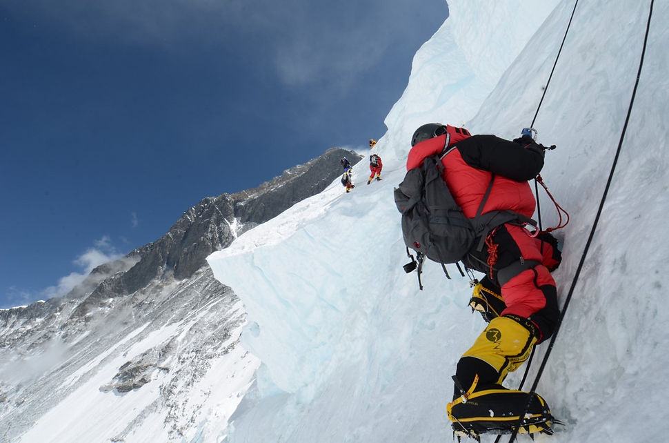
This place is similar to a huge horror-chamber at an amusement park. Only this one is for real. There are countless scary things that can happen here. A crevasse might open under you and an ice-pinnacle can fall on top of you. The entire area can collapse, It's simply not a place for a picnic and most of us just concentrate on getting out of there as quickly as we possibly can. Be sure to always clip in to the ropes. But also to unclip fast if an avalanche strikes. Should that happen, take cover behind a wall or a pinnacle. Jump into a crevasse as a last resort, the avalanche could be small, but will hurl huge ice boulders at you. Watch carefully for ice pinnacles posing in a nasty angle. Do definitely not have your snack brake below one of these, They snap in a second.

Check the ropes and the screws before entering a ladder. Cross the ladders slowly and carefully. Try to fit your crampon between two rails. Sometimes, a nearby avalanche or heavy wind sets the ladder in motion. Just stay calm and focus on each step and you'll be fine. It helps to lean on the ropes, either backwards or forward, depending on the angle of the ladder. The ropes are slack, so leaning on them stretches them and provides a better balance. Even more helpful is if your climbing buddy stretch the ropes for you while you cross the ladder.

Khumbu Icefall Traverse
Occasionally, you will encounter a large wall of ice. Those walls are usually roped, use your jumars. Climb the ropes by kicking your crampons into the ice and then lean on your legs. Don't hang on the rope, it is exhausting and dangerous. Climb the ice fall early in the morning. Climbers usually head out at 4-5 AM. Don't leave BC later than 6 AM. The icefall thaws later in the day and avalanches become more frequent. Plus you'll boil. (Climb time: 5-8 hours not acclimatized, 3-5 hours after acclimatization)

Image Above - Valley of Silence - Western Cwm. The Western Cwm is a broad, flat, gently undulating glacial valley basin terminating at the foot of the Lhotse Face of Mount Everest. It was named by George Mallory when he saw it in 1921 as part of the British Reconnaissance Expedition that was the first to explore the upper sections of Everest, searching for routes for future summit attempts; Cwm is Welsh for "Valley" The Western Cwm is traversed by climbers using the southeast route to the summit of Everest, and is typically accessed by climbing through the Khumbu Icefall. The central section is cut by massive lateral crevasses which bar entrance into the upper Western Cwm. In this section, climbers must cross to the far right, over to the base of Nuptse to a narrow passageway known as the Nuptse corner. From there, climbers can see the upper 2,400 m (7,900 ft) of Everest—the first glimpse of Everest's upper slopes since arriving at base camp. The snow-covered, bowl-shaped slopes surrounding the Western Cwm reflect and amplify solar radiation, warming the valley basin despite its high elevation of 6,000 m (20,000 ft) through 6,800 m (22,300 ft). On a sunny windless day, temperatures can reach up to 35 °C (95 °F).

Camp 1, Valley of Silence
6100 m - 6400 m / 20000 - 21000 ft.
This is a vast, flat area of endless snow, deep crevasses and mountain walls frequently washed by avalanches. Here we set up camp 1. At night we listen to the deep, murmuring cracking sounds under our tents. It is the crevasses opening and closing deep down in the glacier beneath. You keep your fingers crossed that it won't happen right under your tent. At least not just now, while you are in it. Pounding headaches torture you. But it is here that for the first time, just a few steps around a corner, we gain first close sight of Everest.

Image Above - Heading up the Western Cwm, also known as The Valley of Silence, to Camp Two on Everest - Be sure to set camp away from tiny cracks, those possibly hiding the mouths of large crevasses. Climb this area clipped to the fixed ropes, since crevasses lay hidden everywhere under the snow. You could remove your crampons on this climb. Sometimes, weather can turn this usually easy part into a difficult one, due to deep snow and whiteout. Always start out in good time. Stay away from the walls, they avalanche frequently. Later in the season (end of May) this snowy area starts to turn rotten and can turn quite nasty.
(Climb time: 4-7 hours not acclimatized, 3-5 hours after acclimatization)

Image Above Camp 2 - Camp 2
6400 m / 21000 ft.
After an endless, slow march through the silent valley, you reach at last a rocky patch, at the foot of the icy Lhotse wall. This marks camp 2. This place is absolutely stunning. Clouds roll in from the lower ranges of the Himalayas, up the valley and into the camp. While acclimatizing, we spend time looking for cool old climbing gear; left here by all of Everest's climbing history. This is also the last chance to get a decent, prepared meal. We eat all we are handed because soon we'll be surviving on instants only.

Image Above - Camp 2. Don't camp too close to the Everest face, since it avalanches once in a while. Although tempted to idly hang around camp, bring yourself to take walks to the Lhotse face. It will speed acclimatization and relive altitude problems. The walks force you to breathe deeper and faster, thus saturating your body with more oxygen.

Image Above - Lhotse Summits - 6800m - 8000 m / 22300 ft - 26300 ft.
Imagine sliding a fun, icy slope on a sunny winter's day. Only this one is 1200 meter (4000 ft) high. This is not a place to play. The dangerous part is to hang on to rope of dubious strength and to change carabiners between the ropes. You might feel not too clear in your head, especially upon coming down, but it's crucial to concentrate. One slip and you are gone, far higher up than you had intended really.
-711427.jpg)
Image Above - Jim is far right on Lhotse face - Climbers rest on drop back, team prepares to fix summit routes. The Alpine Ascents Everest & Lhotse ...The camp here is a true eagle's nest, placed right out of the wall. Going to the toilet at night is a tedious task to dress and secure oneself. In addition, just to find a spot for it on this narrow platform is tricky enough. But the view is grand and by now you are well on your way to the summit.

Image Above - Waking up at 3 AM Nepal time in my tent at Camp 3 (24,000 ft) on the Lhotse Face (3,000 ft vertical blue ice wall). Getting ready to climb to Camp 4." The climb towards the wall is a flat walk that gets you nicely warmed up. At the wall, you will step in to the ropes and the icy incline begins immediately. After an hour or so, you will reach the "Ice bulge", an icy, bumpy part. After that, it is a pretty uneventful, steep ice climb to C3. Occasionally, you will hear a howling sound and watch rocks catapult down the wall. Blocks of ice sometimes come falling behind climbers. Watch your head, lean on your legs (not the rope) and rest on the lines only occasionally.

The climb will be either easy or hard, depending on weather. A dry, cold season means sheer, blue ice. Maintain your crampons sharp. Deep snow makes the climb easier, but increase the risk of avalanche.
After C3, you will traverse the wall towards the Yellow Band and the Black Turtle. These are rocky sections on the wall, secured by a tangle of old and new ropes. Check the ropes well and watch for rock falls from climbers above you. Another traverse takes you to the foot of the last wall to C4. This part is steep but not very high and soon you'll put your nose above it's edge, thus entering the land of the spirits ' the Deathzone.
(Climbing time: 5-8 hours not acclimatized, 4-6 hours acclimatized.)

Lhotse (black rock middle of shot) from the summit of Everest, looking down at climbers on the Southeast Ridge - Mark Horrell

Image Above - the South Col – 26,000 feet (since Camp IV is in the “death zone,” this camp is a 6-8 hour rest stop on the way to the summit) ... Camp 4, the Deathzone
8000 m / 26000 ft.
Camp 4 sits on a plateau resembling a moonscape. You are at the edge of the atmosphere and the sky owns a strange, dark blue color. It is surely the closest you can get to space on earth.
Only a small climb above camp, you look down the Tibetan plateau with it's vast brown plains, white glaciers and the other alpine giants - Kanchenjunga, Lhotse, Makalu -in the distance. It's all magic and unreal.

Image Above - Camp 4 Death zone area. Yet, this is also the place were the media, fame and fun of BC definitely are gone. Only fear remains on everyone's face. People don't talk a lot. Resting in your tent, feeling weak already, you try to get some sleep as night falls outside. In a couple of hours you will start to put on your gear for the final part of the adventure - the summit push.
The wall towards the summit is steep and dark, you are in the death zone and you can't help thinking that within the next 48 hours, there is a very real risk that you might not live.

Image Above - Into the Death Zone, Go over your gear in daylight. Have everything neatly organized. Drink at least 3 liters of fluid or more if you can. Bring another 2 liters of hot fluid on the climb. Get your axe ready, prepare the Hot Tronics. You will feel great as long as the day is bright but lose spirit fast when night falls. The cold, scary darkness outside is anything but inviting. The wind rustle the tent canvas. You will probably not be able to sleep a wink. Take it easy. As soon as you start out on the climb you will feel much better. Fear is always worse than reality.

Image Above - Mount Everest Death Zone

Image Above - Moving from the South Summit towards the top of Mt. Everest. The treacherous and deadly conditions demand extreme caution and planning.
The summit
8850 m / 29035 ft.
Finally, the hour is come. At about 11 PM we put on the final gear and step out in the night. There, in the distance, we can see a worm of light slowly moving up a dark wall. It's climbers head torches flickering in the dark. It's completely silent. Nobody talks. If you do, you whisper. It is absolutely terrifying and you climb and climb, awaiting fthe first ray of dawn. It's desperately cold. It's steep and at parts very icy. The ice axe and the crampons barely cut into the ice. You need to pee. Forget it. Someone turns around. "Can't go on, good luck".

Mountaineers walk past the Hillary Step while pushing for the summit of Mount Everest on the south face from Nepal, in a file photo from 2009 - A cold, white moon rises from below, but you hardly glance at it or even the bright twinkle of Universe above. The adrenaline keeps your body moving. And then, suddenly, after hours and hours of despair, you notice a thin blue beam of light at the horizon. Sunrise! If you are lucky, now is the time for the fabled mountain ghost. The mountain projects itself onto the morning fog. The shadow towers in front of you like a giant mirage. Beneath lies the world in all its glory, glowing in the rising sun. You feel the warmth and all hope returning.

Hillary and climbing partner Tenzing Norgay were the first to set foot on the summit of Mount Everest, the highest point on earth on May 29, 1953. During the afternoon of 25 April 2015, a magnitude 7.8 earthquake struck Nepal. An avalanche triggered by the quake at Mount Everest killed 22 people and stranded 61 others on the mountain. Because of the powerful forces the Hillary step had partially collapsed resulting in rocks and boulders becoming displaced, There is also loose rubble and unstable blocks with ultimately increases the risk of rock fall.

The Hillary Step was feared by climbers as a bottleneck with long waiting times to the summit of Everest. Some have noted that a snow bridge now makes it easier to climb the passage. However, what happens when the snow bridge drifts or collapses is not clear. Low temperatures and a low oxygen-level would make it unsafe to stay for a prolonged time at this altitude trying to find a safe passage. There is also the danger of rock falls while the rock mass is in the process of settling.
Image above - Climbers are crammed together as they wait to exit the Hillary step,
Traffic chokes the Hillary Step on May 19, 2012. Some climbers spent as long as two hours at this 40-foot rock wall below the summit, losing body heat. Even so, 234 people reached the top on this day. Four climbers died.
PHOTOGRAPH BY SUBIN THAKURI, UTMOST ADVENTURE TREKKING
In later years ascent and descent over the Step has generally been made with the assistance of fixed ropes. usually placed there by the first ascending team of the season. With increasing numbers of people climbing the mountain, the Step frequently becomes a bottleneck, with climbers forced to wait significant amounts of time for their turn on the ropes, leading to problems in getting climbers efficiently up and down the mountain. Only one climber at a time can traverse it. In a good climbing situation it is about a two-hour climb from the South Summit to the Hillary Step, one to two hours to climb the cliff, and then another 20 minutes from the top of the Hillary Step to the summit of Mount Everest.

John Oldring, left, and American guide Willie Benegas (right) are shown in this May 25, 2017 handout image provided Oldring. Oldring a former Alberta politician has become the oldest Canadian to summit Mount Everest. THE CANADIAN PRESS/HO-Red Deer Advocate-John Oldring. You kick your feet to beat the oncoming frostbite. You are at the Balcony, having a short rest, changing to a new oxygen bottle. A ridge lay ahead, and just above you, not far at all, is the South Summit. You begin to enjoy the view, and the possibility of success. Finally, you step up onto the small plateau of the South Summit, and there - just around the corner - is the Everest summit itself!
You have watched it so many times from the distance, and suddenly it is so strangely close. Just right there, only 95 meters / 310 ft away. You can almost touch the white tail of snow.

Image Above - Kuntal Joisher was on top of the world when he became the first vegan to summit Everest in May 2016. This is as far as we came in 1998, so our report on the site had to end here. On this update however - following our 1999 attempt - we are very happy to at last be able to guide you all the way - to the summit!
When you reach the South Summit you are just a couple of hours from your dream come true. But there is one more obstacle in your way. The Knife Ridge. You will gasp upon seeing it. It is steep and looks truly nasty. The ridge towers almost freely over Nepal and Tibet, it's sharp and very steep. Hillary Step is in the middle somewhere, a rock climb in the sky.
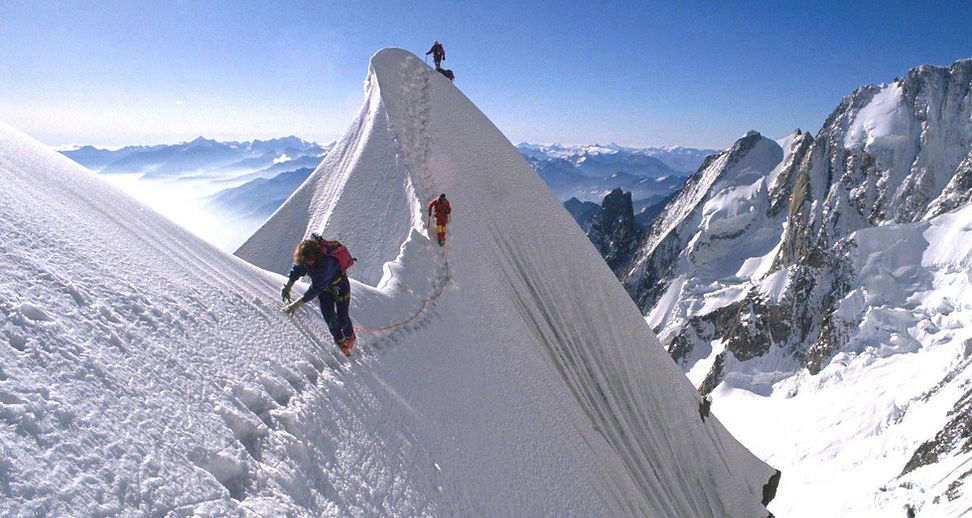
Image Above Cornice traverse’- Between the camp and the peak lies two imposing obstacles, the ‘Cornice traverse’ – a knife-edge horizontal ridge with the 2,400m southwest face on one side and the 3,050m Kangshung face on the other – and then, at the end of the traverse, the daunting ‘Hillary Step’ 12- metre high rock wall. Again through a series of fixed ropes, climbers must ascend this to reach the gentler – albeit heavily exposed – slopes that wind their way to the summit (8,848m).

You step onto the ridge via a small, half open tunnel from South Summit. You climb with your crampons at a sharp, crooked angle towards the side of the ridge. Occasionally, the snow gives way and you slide down for a hairy second. This is not a place to climb without fixing ropes. Clip in carefully, focus on each step and keep moving.
If there is a lot of snow, the ridge could be almost wide and quite nice. We had a dry, sharp climb.

Image Above an elated climber celebrates his victory on reaching the summit of Mount Everest - What It Looks Like to Summit Everest - The Hillary step was, in our opinion, not too bad. Although very exposed at parts, the climb is fast and feels safe, given the conditions. The danger is to get tangled in the ropes. Bring a good knife. Check the ropes well for strength. After the step, you will spot white, strange wave-formations of frozen snow pointing out from the summit. Keep climbing towards them. This section is usually unroped, yet not too steep. Still, be careful and use your axe. You might eagerly look for the summit now, yet all you'll see is a white edge on the horizon. You will not know how far you have left and feel frustrated and tired. Then you reach another white edge, but this time ' it doesn't continue. Behind it, there is instead a slope down. You are peeking down at the North side of Everest. You have reached the summit, friend.
(Climbing time: 8-16 hours)

Image Above - Climber Near the Summit of Mount Everest -Coming down
Most accidents occur upon climbing down. Be sure to have enough oxygen to come back. Don't relax for one moment. The climb is tricky all the way down to the Balcony ' the final ridge before the wall back down to camp 4 and the South Col. Even the wall after the Balcony is dangerous if unroped. You will encounter a couple of bodies of deceased climbers here. In 1998, the last part of the wall towards C4 was not fixed and 8 people took pretty bad falls. Luckily enough, all climbers survived that time. We climb this part roped to each other if the fixed ropes aren't there. If the weather turns bad, the fixed ropes might get buried or you won't be able to see them. Make memory maps on you climb up for this situation. Bring a compass.

Paul Noble reaches the summit of Mt Everest with the North side of Everest from behind. A blue ice bulge will mark the last obstacle back to camp. There are some crevasses there, usually recognizable as streaks of white snow. Avoid them. Finally, you will stumble back down onto the flat, rocky South Col. And take the last exhausted steps towards your tent, throwing yourself into it. And now ' after almost 30 hours of strenuous climb, terror and doubts ' you'll fall into the deepest and happiest sleep of your life.
Exceeded only by your awakening in the morning; the suns rays softly warming you, as you slowly come to a wonderful, triumphant realization; that you actually, really, really made it.
You are an Everest summiteer!
(Climbing time: 4-8 hours).
Kevin Flynn climbs up The Balcony from base camp 4 to attempt his summit.
Here is a list of the many problems climbers face,
Avalanches
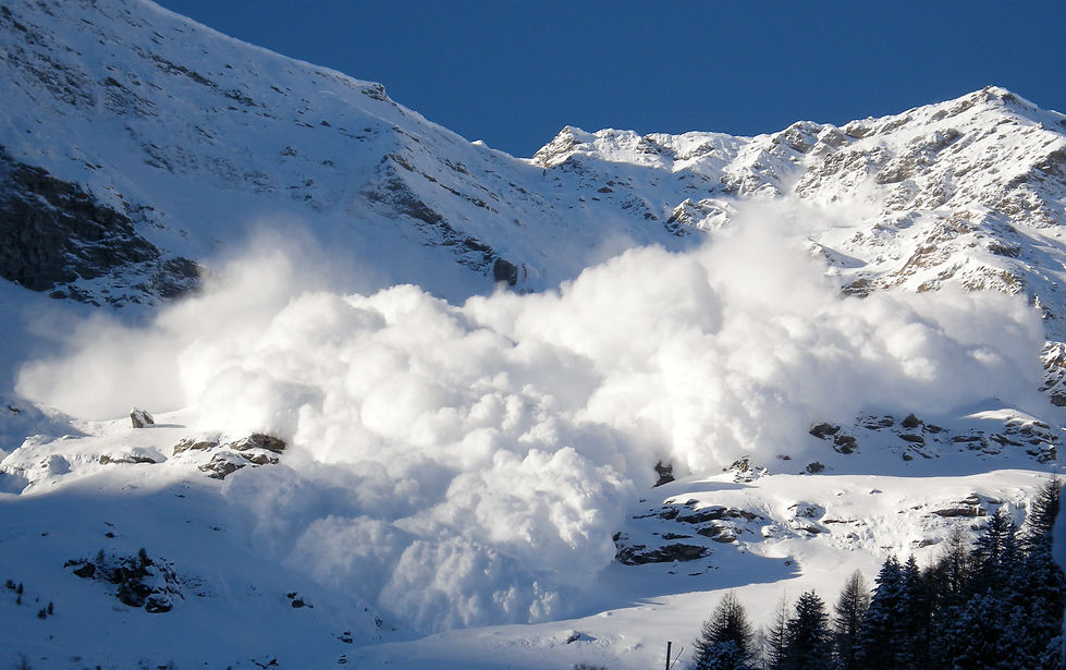
An avalanche (also called a snowslide) is an event that occurs when a cohesive slab of snow lying upon a weaker layer of snow fractures and slides down a steep slope. Avalanches are typically triggered in a starting zone from a mechanical failure in the snowpack (slab avalanche) when the forces of the snow exceed its strength but sometimes only with gradual widening (loose snow avalanche). After initiation, avalanches usually accelerate rapidly and grow in mass and volume as they entrain more snow. If the avalanche moves fast enough, some of the snow may mix with the air forming a powder snow avalanche, which is a type of gravity current.

The load on the snowpack may be only due to gravity, in which case failure may result either from weakening in the snowpack or increased load due to precipitation. Avalanches initiated by this process are known as spontaneous avalanches. Avalanches can also be triggered by other loading conditions such as human or biologically related activities. Seismic activity may also trigger the failure in the snowpack and avalanches. Avalanches are most common during winter or spring but glacier movements may cause ice and snow avalanches at any time of year. In mountainous terrain, avalanches are among the most serious objective natural hazards to life and property, with their destructive capability resulting from their potential to carry enormous masses of snow at high speeds.

Most avalanches occur spontaneously during storms under increased load due to snowfall. The second largest cause of natural avalanches is metamorphic changes in the snowpack such as melting due to solar radiation. Other natural causes include rain, earthquakes, rockfall and icefall. Artificial triggers of avalanches include skiers, snowmobiles, and controlled explosive work. Contrary to popular belief, avalanches are not triggered by loud sound; the pressure from sound is orders of magnitude is too small to trigger an avalanche.

Image Above - Avalanche in Italy Buries Hotel, Leaving up to 30 Missing - Avalanche initiation can start at a point with only a small amount of snow moving initially; this is typical of wet snow avalanches or avalanches in dry unconsolidated snow. However, if the snow has sintered into a stiff slab overlying a weak layer then fractures can propagate very rapidly, so that a large volume of snow, that may be thousands of cubic meters, can start moving almost simultaneously. Slab avalanches form frequently in snow that has been deposited, or redeposited by wind. They have the characteristic appearance of a block (slab) of snow cut out from its surroundings by fractures. Elements of slab avalanches include the following: a crown fracture at the top of the start zone, flank fractures on the sides of the start zones, and a fracture at the bottom called the stauchwall. The crown and flank fractures are vertical walls in the snow delineating the snow that was entrained in the avalanche from the snow that remained on the slope. Slabs can vary in thickness from a few centimetres to three metres. Slab avalanches account for around 90% of avalanche-related fatalities in backcountry users.

Scientists try to work out how the earthquake and subsequent avalanche at base camp Mt Everest took the lives of at least 22 climbers on 25th April 2015. The largest avalanches form turbulent suspension currents known as powder snow avalanches or mixed avalanches. These consist of a powder cloud, which overlies a dense avalanche. They can form from any type of snow or initiation mechanism, but usually occur with fresh dry powder. They can exceed speeds of 300 kilometres per hour (190 mph), and masses of 10000000 tonnes; their flows can travel long distances along flat valley bottoms and even uphill for short distances.

An injured person is loaded onto a rescue helicopter at Everest Base Camp on April 26 2015 following the Nepal earthquake. As an avalanche moves down a slope it follows a certain pathway that is dependent on the slope's degree of steepness and the volume of snow/ice involved in the mass movement. The origin of an avalanche is called the Starting Point and typically occurs on a 30–45 degree slope. The body of the pathway is called the Track of the avalanche and usually occurs on a 20–30 degree slope. When the avalanche loses its momentum and eventually stops it reaches the Runout Zone. This usually occurs when the slope has reached a steepness that is less than 20 degrees. These degrees are not consistently true due to the fact that each avalanche is unique depending on the stability of the snowpack that it was derived from as well as the environmental or human influences that triggered the mass movement. An ice avalanche occurs when a large piece of ice, such as from a serac or calving glacier, falls onto ice (such as the Khumbu Icefall), triggering a movement of broken ice chunks. The resulting movement is more analogous to a rockfall or a landslide than a snow avalanche. They are typically very difficult to predict and almost impossible to mitigate.

In contrast to powder snow avalanches, wet snow avalanches are a low velocity suspension of snow and water, with the flow confined to the track surface (McClung, first edition 1999, page 108). The low speed of travel is due to the friction between the sliding surface of the track and the water saturated flow. Despite the low speed of travel (~10–40 km/h), wet snow avalanches are capable of generating powerful destructive forces, due to the large mass and density. The body of the flow of a wet snow avalanche can plough through soft snow, and can scour boulders, earth, trees, and other vegetation; leaving exposed and often scored ground in the avalanche track. Wet snow avalanches can be initiated from either loose snow releases, or slab releases, and only occur in snow packs that are water saturated and isothermally equilibrated to the melting point of water. The isothermal characteristic of wet snow avalanches has led to the secondary term of isothermal slides found in the literature (for example in Daffern, 1999, page 93). At temperate latitudes wet snow avalanches are frequently associated with climatic avalanche cycles at the end of the winter season, when there is significant daytime warming.

Notable avalanches
Two avalanches occurred in March 1910 in the Cascade and Selkirk Mountain ranges; On March 1 the Wellington avalanche killed 96 in Washington state, Unites States. Three days later 62 railroad workers were killed in the Rogers Pass avalanche in British Columbia, Canada.

Image Above - In 1910, a destroyed train and other debris from an avalanche rocked the railroad town of Wellington, Wash., the scene of the worst avalanche disaster in U.S. history, when two passenger trains were swept away and nearly 100 people were killed. (File Associated Press)

Image Above - Austrian troops on the mountain tops - During World War I an estimated 40,000 to 80,000 soldiers died as a result of avalanches during the mountain campaign in the Alps at the Austrian -Italian front, many of which were caused by artillery fire. Some 10,000 men, from both sides, lost their lives in avalanches in December 1916.

Image Above - An avalanche in Vals, southeast Switzerland, claimed 19 lives in January 1951 (Keystone) - In the Northern Hemisphere winter of 1950–1951 approximately 649 avalanches were recorded in a three-month period throughout the Alps in Austria, France, Switzerland, Italy and Germany. This series of avalanches killed around 265 people and was termed the Winter of Terror.

Image Above - A search for victims after the Vallascia avalanche in Airolo in southern Switzerland on February 12, 1951 (Keystone/Ernst Baumann)

A sentry stands watch with a siren after an avalanche claimed ten lives in Airolo on February 12, 1951. (Keystone/Ernst Baumann)

Mailbags are dropped by parachute from a plane for a village cut off from the outside world by avalanches in January 1951. (Keystone)

Salvage work after the devastating avalanche in Andermatt, January 1951. (Keystone)

Canton Graubünden in January 1951. (Keystone)

The burial of ten avalanche victims took place in February 1951 in Airolo. (Keystone)
The catastrophic winter of 1951 led to calls for action to keep the mountain population safe. Basic research and practical support were needed, as well as an avalanche warning system.

Avalanche barriers on the Vallascia over Airolo were erected in October 1954 to prevent a catastrophe like the one of 1951. (Keystone)

A training course for mountain rescue dogs, which were used by the army until the Swiss Alpine Club took over the training after the Second World War. (ETH Bibliothek)
Since 1953 more efficient structures have been developed, such as protection forests planted on critical mountain slopes, hazard maps and the expansion of the forecast by the Institute for Snow and Avalanche Research (SLF). The improvements showed their value in 1999 when there were a similar number of avalanches as in 1951 but fewer fatalities. This was attributed to the measures taken as a result of the "winter of terror".

The Federal Institute for Snow and Avalanche Research taking readings of data from an open-air barograph in canton Graubünden in January 1953 (Keystone)
Today, with ongoing developments in avalanche safety, UNESCO has included Switzerland’s handling of avalanche risk in the Representative List of the Intangible Cultural Heritage of Humanity.

A mountain climbing camp on Lenin Peak, in what is now Kyrgyzstan, was wiped out in 1990 when an earthquake triggered a large avalanche that overran the camp. Forty-three climbers were killed. In 1993, the Baybert Uzengili avalanche killed 60 individuals in Uzengili in the province of Bayburt, Turkey.

A large avalanche in Montroc, France in 1999, 300,000 cubic metres of snow slid on a 30° slope, achieving a speed in the region of 100 km/h (62 mph). It killed 12 people in their chalets under 100,000 tons of snow, 5 meters (16 feet) deep. The mayor of Chamonix was convicted of second-degree murder for not evacuating the area, but received a suspended sentence.

The small Austrian village of Galtur was hit by the Galtur avalanche in 1999. The village was thought to be in a safe zone but the avalanche was exceptionally large and flowed into the village. Thirty-one people died.

On December 1, 2000, the Glory Bowl Avalanche formed on Mt. Glory which is located within the Teton Mountain Range in Wyoming, United States. Joel Roof was snowboarding recreationally in this backcountry, bowl-shaped run and triggered the avalanche. He was carried nearly 2,000 feet to the base of the mountain and was not successfully rescued.


2014, April, Jackson, Mt Glory, northface, Teton Pass

Falling rocks
A rockfall or rock-fall refers to quantities of rock freely falling from a cliff face. The term is also used for collapse of rock from roof or walls of mine or quarry workings. A rockfall is a fragment of rock (a block) detached by sliding, toppling, or falling, that falls along a vertical or sub-vertical cliff, proceeds down slope by bouncing and flying along ballistic trajectories or by rolling on talus or debris slopes,” (Varnes, 1978). Alternatively, a "rockfall is the natural downward motion of a detached block or series of blocks with a small volume involving free falling, bouncing, rolling, and sliding". The mode of failure differs from that of a rockslide.

Seven tourists died when they were struck by huge rocks tumbling down a mountain in one of China's most popular beauty spots, state media said.
The rocks hit the group of travellers as they waited to board boats in the Diecai Mountain scenic area in Guilin, China Radio International (CRI) said.
Pictures posted online showed rocks -- one as big as a metre (three feet) wide -- resting on broken pavement splattered with pools of blood with handbags, shoes and other personal items scattered across the ground.
"Four were killed at the scene and four others injured," CRI said in a report on its website. "Three of the injured later died in hospital."
The official news agency Xinhua said an "unknown" number of injured were being treated in a hospital in Guilin, in the southern region of Guangxi.
Xinhua said the fatalities were the result of a "huge boulder", while CRI and state broadcaster China Central Television (CCTV) said "rocks" fell down the mountain.
CCTV said in a Tweet that 19 people were injured, with eight of the casualties from Taiwan.
The area is known for its karst mountains and caves, and is a popular site for Chinese and foreign visitors, with Diecai Mountain -- also known as Folded Brocade Hill -- offering stunning views.

Favourable geology and climate are the principal causal mechanisms of rockfall, factors that include intact condition of the rock mass, discontinuities within the rockmass, weathering susceptibility, ground water, freeze-thaw, root-wedging, and external stresses. A tree may be blown by the wind, and this causes a pressure at the root level and this loosens rocks and can trigger a fall. The pieces of rock collect at the bottom creating a talus or scree. Rocks falling from the cliff may dislodge other rocks and serve to create another mass wasting process, for example an avalanche. Typically, rockfall events are mitigated in one of two ways: either by passive mitigation or active mitigation. Passive mitigation is where only the effects of the rockfall event are mitigated and are generally employed in the deposition or run-out zones, such as through the use of drape nets, rockfall catchment fences, diversion dams, etc. The rockfall still takes place but an attempt is made to control the outcome. In contrast, active mitigation is carried out in the initiation zone and prevents the rockfall event from ever occurring. Some examples of these measures are rock bolting, slope retention systems, shotcrete, etec. Other active measures might be by changing the geographic or climatic characteristics in the initiation zone, e.g. altering slope geometry, dewatering the slope, revegetation, etc. Design guides of passive measures have been proposed by Ritchie (1963), Pierson et al. (2001), Pantelidis (2010) and Bar et al. (2016)

Newcastle mountaineer Michael Davis died after a falling rock severed his climbing ropes as he descended a peak near Mount Everest in eastern Nepal. Mr Davis was from Wallsend and was a former Ausgrid engineer, he was 33 years old. The terrible tragedy happened while he was climbing down the 6812 metre high Ama Dablam mountain in the Himalayas.
It was Mr Davis’ first trip to the world’s highest mountain range, but he had climbed two other peaks earlier in the five-week expedition. Expedition organiser Tshering Pande Bhote, the managing director at Top Himalaya Guides, said Mr Davis had fallen to his death below the highest camp on the mountain. The accident had occurred when the climbers, including high-altitude guides, were descending from the camp after a strong wind.
“The mountaineer fell to his death after a huge rock damaged the ropes he was using to descend the mountain,” Mr Bhote said.
He said other members of the expedition were safe.
Ama Dablam, which means “mother’s necklace”, has two long ridges leading to the steep summit. It is one of the most popular climbing mountains in the Himalayas. An aerial rescue operation retrieved Mr Davis’ body immediately after the accident.
“His body has already been airlifted to Kathmandu for post-mortem,” Mr Bhote told the newspaper. Michael's brother Nick and his parents Geoff and Kathy flew out to Nepal as soon as they could to find out more on there loved ones death. Michael's sister in law has said that the family had spoken to a Norwegian doctor who was climbing with the group at the time of the accident.
“He said Michael had double safety ropes all connected,” she said. “He kind of indicated the rock hit Michael as well as cutting the rope.
“He was there when it happened and accompanied his body back to Kathmandu.”

Ama Dablam is a mountain in the Himalaya range of eastern Nepal, The main peak is 6,812 metres (22,349 ft), the lower western peak is 6,170 metres (20,243 ft). Ama Dablam means "Mother's necklace"; the long ridges on each side like the arms of a mother (ama) protecting her child, and the hanging glacier thought of as the dablam, the traditional double-pendant containing pictures of the gods, worn by Sherpa women. For several days, Ama Dablam dominates the eastern sky for anyone trekking to Mount Everest basecamp. For its soaring ridges and steep faces Ama Dablam is sometimes referred as the "Matterhorn of the Himalayas"

Image Above - Monika and Lhakpa Gelbu Sherpa at the summit of AmaDablam. Ama Dablam was first climbed on 13 March 1961 by Mike Gill (NZ), Barry Bishop (USA), Mike Ward (UK) and Wally Romanes (NZ) via the Southwest Ridge. They were well-acclimatized to altitude, having wintered over at 5800 meters near the base of the peak as part of the Silver Hut Scientific Expedition of 1960-61, led by Sir Edmund Hillary.

Image Above - Mount Ama Dablam Photo - Night photography of the Ama Dablam base camp - Ama Dablam is the third most popular Himalayan peak for permitted expeditions. The most popular route by far is the Southwest Ridge (right skyline in the photo).[6] Climbers typically set up three camps along the ridge with camp 3 just below and to the right of the hanging glacier, the Dablam. Any ice that calves off the glacier typically goes left, away from the camp. However, a 2006 avalanche proved that this is not always the case. A climbing permit and a liaison officer are required when attempting Ama Dablam. As with Mt. Everest, the best climbing months are April–May (before the monsoon) and September - October.

On the night of 13/14 November 2006, a large serac collapse occurred from the hanging glacier, which swept away several tents at Camp 3, killing six climbers (3 European, 3 Sherpa). Eyewitness testimony indicates that Camp 3 had not been sited in an unusual or abnormally dangerous spot, and that the serac fall was of such magnitude as to render the specific placing of the tents at Camp 3 irrelevant.

On November 11, 2017, Valery Rozov was killed when he jumped from the mountain in a wingsuit and struck a cliff.

In September 1997, Bear Grylls, a British adventurer and television presenter became the youngest Briton to climb Ama Dablam (aged 23). He also holds The World Record For The Highest Open-Air Formal Dinner Party, Held In A Hot-Air Balloon At 7,600m. Photo: BearGrylls.com

Nick Harper is one the UK’s best kept musical secrets. For over two decades, he has been dazzling audiences, reviewers & fellow artists alike with his heady mix of virtuosity, boyish charm, showmanship & sheer bravado. An imagination bursting with ideas has seen Nick release 11 solo albums to critical acclaim, earning a Number 1 spot in the charts with the seminal hit ‘Blue Sky Thinking’. The singer/songwriter Nick Harper has a track on his 2010 album The Last Guitar entitled "Ama Dablam.

Image peak Ama Dablam is present on the label of bottled tap water Aqua Minerale (Russian: Аква Минерале),PepsiCo in Russia as well as included in the image of the Trademark.

Brandon Kampschuur was snowboarding on Glacier des Rognons in the Chamonix region back in February when he found himself 50 feet below the surface, perched on a snow bridge inside a crevasse. Luckily, he managed to make contact with the guide he was riding with, and a rescue operation was quickly put into motion.
Brandon manages to stay surprisingly calm, and documents some of his thoughts and feelings on camera while he’s waiting to be roped out of there.
It’s pretty clear that Brandon got incredibly lucky here, being hauled out only with a bruised elbow, but it goes to show that even when you’re with trained professionals who know the terrain, riding on glaciated terrain is unpredictable and dangerous. Never ride on them alone and without taking the necessary precautions, because getting stuck down one of these suckers sure doesn’t look like a fun way to go.

Image Above - Brandon Kampschuur
While skiing this past December, Jamie Mullner fell into a huge crevasse, but he had the GoPro recording, how epic is that?

Crevasse rescue is the process of retrieving a climber from a crevasse in a glacier, Because of the frequency with which climbers break through the snow over a crevasse and fall in, crevasse rescue technique is a standard part of climbing education.
The basic assumption of crevasse rescue is that two or more climbers are tied together with a climbing rope, forming a rope team: a standard number is three, one on each end and one in the middle, which means there are two available to hold a falling climber, but is not as complicated to manage as large numbers of people attached to a single rope.

Image Above - Mt. Rainier - Crevasse Rescue School - When the snow gives way under the victim, the others on the team must immediately prepare for the impending yanks, usually by flopping down and digging ice axes and knees (or boots if not wearing crampons) into the snow, facing away from the crevasse if possible, and holding tight until everything stops moving. Many crevasses are small or slanted, and the fallen climber may be able to escape by digging or wiggling out; but if the climber is hanging in midair, one of several rescue techniques will need to be used.

Image Above - Crevasse Rescue Course - Baker Mountain Guides - The first step is to stabilize the situation and free up the climbers still outside the crevasse. This can be done in several ways, typically involving one person anchoring the rope with boot-axe belay, while the other person probes for the edge of the crevasse and attempts to communicate with the victim. The main force technique is plausible when there are multiple rope teams; everybody simply hauls on the rope attached to the victim, drawing it over an axe shaft or other hard object so the rope friction does not cut a deep groove at the edge of the crevasse making it harder for the climber to get out.

The Z-pulley technique is a moderately complicated arrangement using a small moving pulley to reduce the hauling effort. The single-pulley technique entails dropping a pulley attached to another length of rope, which the victim clips to the climbing harness. If the climber in the crevasse is able to move, he or she may be able to use prusik knots with slings or Jumars to ascend the rope. The related bilgeri technique involves the use of a second rope, and prusik knots by the rescuers instead of the victim. Once the victim reaches the lip of the crevasse, some combination of hauling and flailing will be needed to get over it, since the victim is still suspended by the waist, with feet still in the crevasse.

Image Above - Jim Wickwire on summit (K2) (Courtesy of Jim Wickwire) - Jim is attending to his air tank and valve. A 14-person expedition with strong Seattle roots conquered K2 in September 1978, the first Americans to do so. The climb was a monument to grit and determination, beset by adversity, yet successful at the point when it seemed another failure was inevitable.

Although the mechanical principle of rescue is simple, the reality is far messier. The victim may be injured and/or disoriented from the fall, the rescuers on the scene may be anxious or uncertain, equipment and ropes are scattered everywhere, and everybody will likely already be exhausted and out of breath because of the climbing and altitude. It may also be that additional crevasses are nearby, and rescuers have died in unsuspected crevasses because they unroped in order to set up a rescue of the first victim. The experience of world-class climbers Jim Wickwire and Chris Kerrebrock on Mount McKinley (since renamed Denali) in 1981 shows how much can go wrong. Only a two-person team, when Kerrebrock fell in, Wickwire was pulled in after. Wickwire managed to get out of the crevasse, but Kerrebrock was jammed in the bottom, head down. Wickwire tried to pull him out, but his shoulder had been dislocated, and he didn't have the strength; Kerrebrock eventually died of hypothermia, and Wickwire had to run the gauntlet of the remaining crevasses alone.


Image Above - Ed Hommer
Image Above - Chris Kerrebrock
A double amputee training to climb Mount Everest was struck and killed by a falling rock on Mount Rainier early Monday.
National Park Service spokeswoman Maria Gillett says Ed Hommer, a 46-year-old pilot from Duluth, Minn., was killed instantly when he was struck by a basketball-sized rock.
Gillett said rangers received a cell phone call just before dawn Monday from team leader Jim Wickwire of Seattle. He said one member of a four-member party on Disappointment Cleaver, at the 11,700-foot level of the 14,411-foot mountain, had been struck and killed by a rock.
Disappointment Cleaver is the most dangerous part of the climb, especially at this time of year when melting snow and ice have exposed more of the rock.
Park spokeswoman Lee Taylor said Hommer's body was removed by helicopter at midday Monday. The other members of the party hiked down to Camp Muir, at 10,080 feet, where they were met by a helicopter and taken off the mountain.
Hommer, who lost his legs in an airplane crash on Mount McKinley in 1981, used carbon-fiber and titanium prostheses and had hoped to be the first double amputee to scale Mount Everest.
Last October, his quest to scale Everest was called off when he and his team, hampered by bad weather, had to turn back 3,000 feet short of the summit.
Since he lost his legs, Hommer has gone on climbs in Alaska and the Himalayas. In 1998, he tried to climb Mount McKinley but was thwarted by storms and high winds. The next year, he reached the 20,320-foot summit, the highest in North America.
Besides Wickwire, the other members of Hommer's Mount Rainier climbing team were Tim Herlehy and Scott Rose, both of San Diego.